Home › Forest Grove
Forest Grove sits on 0.14 square miles of mapped surface water — more than any other city in this corridor — which changes what a French drain has to do and when the ground is ready for the work.
French drains and surface drainage systems are designed to intercept water before it reaches a structure or saturates a yard — but the engineering behind each installation depends entirely on where the water is coming from. In Forest Grove, 0.14 of the city’s 5.88 square miles is mapped surface water, which means many residential and commercial properties sit close enough to a water body that their subsurface conditions are shaped by that proximity all year long. Hillsboro Excavation Co. installs French drains, foundation perimeter systems, and surface channel networks sized to the actual hydrology of each Forest Grove site — not to a generic Oregon drainage specification that assumes a standard inland water table.
The distinction matters because a water table that is influenced by nearby surface water behaves differently than one driven by rainfall alone. During the October-through-May wet season, a property that borders a creek or pond sees its water table track the level of that water body. Rain adds to the load, but the table was already elevated before the first storm of the season. A French drain installed without accounting for that baseline will fill from the bottom up during a heavy rain event, lose its capacity before the surface runoff even arrives, and leave the homeowner wondering why a brand-new drain is not performing. Designing around that reality requires measuring where the water table sits before any pipe diameter or outlet elevation is chosen.
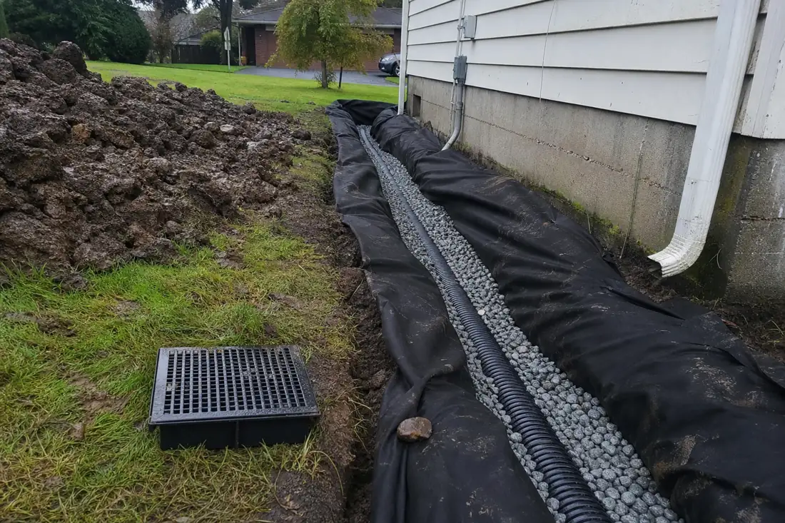
A drainage project in Forest Grove typically involves more investigation than a comparable job on a purely upland site. Each phase of the work affects how the finished system performs through multiple wet seasons, and skipping any step produces a system that appears to work initially but degrades once the water table reaches its seasonal peak.
Each of these steps has a straightforward version for a standard inland lot and a more demanding version for a site where surface water is a factor. Understanding which version your property requires before the project starts is what separates an accurate quote from a change-order surprise. It’s worth discussing site conditions with excavation contractors in Hillsboro, OR who already know Washington County’s mapped water features and the permit triggers that come with them.
A French drain on a standard inland lot is a surface-interception tool: it catches rain-driven water before it reaches a wall or a low point and routes it away by gravity. That description covers most of what the drain does. For properties near Forest Grove’s surface water, that description is incomplete. The Tualatin Valley’s silty clay soils hold moisture for weeks after rainfall stops, and near a water body, the subsurface moisture level is continuously recharged laterally from the adjoining water. The practical effect is that soil near surface water stays near field capacity — saturated enough to be plastic and weak — well into late spring, when inland properties have already dried enough for normal landscaping and construction activity. Work windows that open in March elsewhere may not open here until late April or May, and scheduling excavation without that knowledge produces delays.
When a French drain’s aggregate bed sits below the seasonal high water table, hydrostatic pressure pushes water up into the stone from below. If the outlet elevation is not set well above that table level, the system reaches equilibrium rather than draining: water enters the pipe but cannot leave faster than it arrives, and effective capacity drops to near zero during the weeks it is most needed. The solution is either a higher outlet combined with careful grading or, on low-lying sites, a pump that actively removes water to a discharge point above the water table elevation. This is a materially different project scope than a simple gravity French drain, and it requires site-specific outlet elevation measurements before design decisions are made. Our Hillsboro excavation crews take those measurements at the outset rather than discovering the constraint after the trench is already open.
The shorter workable season near surface water also concentrates demand. Property owners who discover drainage problems during the wet months often want work done immediately, but that is frequently the worst time to excavate near a water body in Washington County: soil is at its most plastic, erosion-control requirements are at their most demanding, and any disturbance that reaches a sensitive area buffer triggers Clean Water Services review. Timing drainage work for the dry months — June through September — reduces permitting friction, allows the aggregate to be placed without immediately saturating, and makes final grade restoration far more predictable.
Forest Grove was platted in 1850, making some of its residential properties among the oldest continuously occupied parcels in the Tualatin Valley. The original drainage on those lots — when it exists at all — was built before Washington County adopted modern stormwater standards, before Clean Water Services had jurisdiction over sensitive areas, and before anyone was mapping water body setbacks that now determine what you can disturb and how. On older properties, the first cost that surprises owners is the reconnaissance phase: before any new French drain can be installed, the crew has to determine whether existing subsurface drainage is present, where it runs, what condition it is in, and whether it is still connected to a functioning outlet. A clay tile drain installed in 1940 running at an unknown angle is a hazard to cut into blind, and it may be delivering water to a neighbor’s lot in a way that creates liability if it is interrupted. That investigation adds real time and cost before any excavation begins.
On the permit side, ground-disturbing work near a Clean Water Services Sensitive Area or its setback buffer requires an erosion and sediment control plan that functions under actual winter storm conditions — not one that passes a dry-weather site inspection and then fails in a January storm when a slope is receiving two inches of rain over 24 hours. The Hillsboro excavation crew installs erosion controls calibrated to the storm events this part of Washington County actually receives: straw wattles and rock check dams for slope interception, stabilized construction entrances to contain sediment, and staged work sequences that minimize exposed soil area at any one time. For projects that disturb an acre or more, the Oregon DEQ 1200-C stormwater general permit applies independently of any local Clean Water Services authorization, and a Stormwater Pollution Prevention Plan must be in place before ground is broken. Getting both the local and state permit conditions right before the project starts avoids stop-work notices and the remediation costs that follow them.
Surface water proximity, a seasonally high water table, and century-old subsurface infrastructure make Forest Grove drainage work more demanding than most — talk to excavation contractors in Hillsboro, OR who understand what that means before the first shovel goes in.
A French drain relies on gravity to carry water away from a site. When the water table rises above the pipe outlet elevation, gravity can no longer drain the system and water backs up into the aggregate bed. Near Forest Grove’s mapped water bodies, the seasonal high table can be quite close to the surface for months at a time. Sizing the pipe and setting the outlet elevation to stay above that table — or adding a pump where gravity is not enough — determines whether the drain works in a wet winter or just in light rain.
Yes. Work that disturbs soil within a Clean Water Services Sensitive Area or its adjacent buffer triggers a Service Provider Letter or other Clean Water Services authorization before excavation begins. Forest Grove’s water bodies create these buffers in areas that may not be obvious from a property survey. Projects over an acre also require the Oregon DEQ 1200-C stormwater general permit separately. The right starting point is a site review to identify which mapped water features are within range of the proposed work and what that means for permit sequencing.
On properties platted before the mid-twentieth century, it is common to find clay tile drains, rubble-filled trenches, or older concrete conduit that does not appear on any current record. A crew can probe and dig test holes to locate buried drainage before committing to a new system. That reconnaissance matters because cutting an active drain blind can redirect water to an unintended location and because the existing system, if it is still functional, may be part of a more cost-effective solution than full replacement.
Clean Water Services requires erosion and sediment control measures that prevent runoff from reaching a waterway during construction. In practice that means filter fabric or straw wattle barriers along the downhill perimeter of any disturbed area, stabilized staging zones to prevent soil tracking, and rapid seeding or matting of any bare soil left overnight. Near a mapped water body, those controls are inspected more rigorously because runoff has a short path into the waterway rather than traveling across upland before reaching any drainage. Controls that satisfy inspection in dry weather have to be sized for the storm events that actually occur here in winter.
Drainage costs in Forest Grove vary more than in many areas because site conditions near surface water introduce variables that don’t exist on standard inland lots. A basic gravity French drain on a simple slope might run in the low thousands. A system that requires pre-dig water table investigation, outlet elevation engineering, pump installation for a low-lying site, or erosion control measures meeting sensitive area standards will cost more — sometimes substantially. Reconnaissance on older properties with unknown underground infrastructure adds further cost before any pipe goes in. An accurate number requires a site visit, not a phone estimate, because the site conditions here drive the scope.
June through September is the most practical window for drainage work near Forest Grove’s surface water. During those months the water table is at its seasonal low, which makes it easier to verify the outlet elevation will stay above it, allows the aggregate bed to be placed without immediately saturating, and reduces the erosion-control burden because storm risk is low. Wet-season work between October and May is possible but introduces more complexity: soil near water bodies is plastic and slow to stabilize, erosion controls must be heavier, and Clean Water Services inspects more frequently when rain is active. Scheduling in the dry months typically means a more predictable project timeline and fewer weather-related delays.
Tell us about your project and we will come walk the site and give you a straight, itemized quote — no obligation, no pressure. Call us, or send the form and we will get back to you the same business day.
Call or text and reach us directly. We answer during business hours and return every message.
(971) 397-9361Hours: Mon–Sat, 7am–6pm